Tuesday, June 03, 2014

WWDC14 - Birlikte çalışan cihazlar, geliştiriciler için yeni bir dil ve Android'den ödünç alınan yeni özellikler


Apple'ın CEO'su Tim Cook, WWDC14 açılış konuşmasında iOS7'nin mevcut kullanıcılarının %89'una ulaştığını vurguladı. Hemen ardından da Android kullanıcılarının yeni sürümlere geçişinin ne kadar yavaş olduğundan, Android'in güvenlik sorunlarından ve son yılda 130M milyon kullanıcının farklı platformlardan gelenler olmasının üzerinde durdu.

2 saatlik konuşma ilerledikçe, Android'in güzel özelliklerinden iOS8'e dâhil edilenlerin ne kadar fazla olduğunu görünce, bu vurgunun anlamını daha iyi anlıyorsunuz.

Apple iOS8 ile uygulamaların birbirlerine hizmet verip ekran sunabileceklerinden, 3. parti klavye uygulamalarından, kendi "predictive" klavyelerinden, uygulamaların diğer uygulamalar için document provider olabilmesinden ve en son da (sadece Notification Center'da da olsa) widget'lardan bahsettikçe, bir Android kullanıcısı olarak hep Android'i hatırladım. Siri bile artık, "OK Google" der gibi "Hey Siri" diyerek ayağa kaldırılabiliyor (hâlâ tam Türkçe desteğinden bahsedilmese de).


Evdeki tüm Apple cihazları birlikte çalışıyor

Tüm bunlar bir yana, Apple bu yıl beklenildiği gibi OSX'in yeni sürümü olan Yosemite'den ve iOS8'den bahsetti. Yosemite, yarı saydam pencerelerle görsel olarak biraz iOS7'yi andırırken, Apple yoğun olarak SpotLight Search'ün artık bilgisayar üzerinde yaptığı arama yanında İnternet'i, Wikipedia'yı, AppStore'u, iTunes'u nasıl kolaylıkla aradığını anlattı örnek kullanım senaryolarıyla.

Birçoğumuzun evini iPhone'uyla, iPad'iyle belki de Macbook ve Apple TV'siyle işgal eden Apple; bu kadar çok cihazın birbirini tamamlamasını, birinin yeteneklerini diğerinden kullanabilmesini de sağladı Yosemite ve iOS8 ile. "Continuity" özelliğiyle telefonda başladığınız e-postayı iPad'de bitirebiliyor, iPad'den ve Mac'den SMS alıp verme, çağrı başlatma ve yanıtlama olanağına kavuşuyorsunuz. Hatta telefonunuzun evde nerede olduğuna aldırmadan Mac'iniz telefonunuzdaki hotspot'u açarak kendine İnternet erişimi bile sağlayabiliyor.

Touch ID

iPhone 5S'in en yenilikçi özelliklerinden birisi şüphe yok ki, parmak izi tarayıcısı idi. iOS7 ile bu özellik sadece Apple uygulamaları tarafından ekran kilidini kaldırmak ve AppStore'da uygulama satın almak için kullanılırken, iOS8 ile tüm geliştiricilerin kullanımına açılıyor.

Sağlık ve Akıllı Ev

Bunlar yanında uzun zamandır dedikodu şeklinde konuşulan sağlık ve akıllı ev alanında da HealthKit ve HomeKit altyapılarının da gerçek olduğunu duyduk Tim Cook’un ağzından.

HealthKit, şu an adımsayarlar, tartılar, tansiyon ölçerler gibi değişik cihazlar ve uygulamalarca tutulan sağlık verilerinizi ortak bir yerde güvenli bir şekilde tutarken iOS8 ile gelecek olan Health uygulamasıyla hepsine topluca erişebilmenizi de sağlıyor. Hatta Mayo Clinic gibi hastanelerin, hastalarının yaptıkları ölçümlerden anında haberdar olabilmesi ve önleyici aksiyonlar alabilmesini de sağlıyor.


HomeKit ise evdeki yine farklı üreticiler tarafından üretilen ve farklı uygulamalarca kontrol edilen kamera, ışık, kapı, priz gibi akıllı cihazların ortak bir noktadan kontrol edilebilmesini sağlıyor. Üstelik Siri entegrasyonuyla "ışıkları aç" diye sesinizle kontrol etmenizi de sağlıyor.

AppStore

1.2 milyon uygulamaya, haftalık 300 milyon kullanıcı ziyaretine ulaşan AppStore'daki "discovery" sorununundan Apple'in haberdar olmaması, elbette mümkün değil. Apple bu soruna çözüm olarak AppStore uygulamasındaki kategorileri inceleyebileceğiniz "Explore" ve trending searches sekmelerini düşünmüş.

Kullanıcıların uygulamaları topluca ve indirimli alabilmelerini sağlayacak App Bundles özelliği de getirilirken, bir başka sorun olan ailelerin çocuklarının kontrolsüz AppStore harcamalarına da ebeveyn kontrolü sağlayacak bir çözüm getirilmiş. Özellikle bu ebeveyn kontrolü birçok uygulama için gelir kaybı anlamına geliyor olabilir, ne dersiniz?


Geliştiriciler için AppStore'a uygulamanızı gönderirken ekran görüntüsü koyabilseniz de, uygulamayı tanıtıcı bir videoyu AppStore'a gönderemiyordunuz. GooglePlay'de halihazırda olan bu yetenek de artık AppStore'da mümkün olabilecek.

Sunucu kodu işini Apple hallediyor

Bir mobil uygulama yazmak sıklıkla tek başına yeterli olmayabiliyor. Bazı işleri yapmak için veya en basitinden push göndermek için sunucu tarafında da geliştirme yapmanız ve hatta bunun için sunuculara sahip olmanız gerekebiliyor. Bu gibi hizmetleri veren değişik şirketler varken, Apple CloudKit ile bu işi ücretsiz olarak (belli sınırlar dâhilinde) kendi üzerine aldığını açıkladı. Detaylarını ilerleyen günlerde göreceğiz, ancak bu geliştiriciler için bazı işleri kolaylaştırıp, iOS geliştiricilerine Android geliştiricilerine karşın avantaj sağlayabilecek gibi görünüyor.

Oyun geliştiriciler için

iOS7 ile 2-boyutlu oyun geliştiriciler için kolaylıklar sağlayan, fizik motoru getiren SpriteKit'i geliştiricilere sunan Apple, iOS8 ile benzer birşeyi 3-boyutlu oyun geliştiricileri için SceneKit ve Metal isimli altyapılarla sunuyor.

Yepyeni bir dil, Swift

Apple "C olmayan bir Objective C" hayallerinden bahsederek, geliştiriciler için daha güvenli, daha hızlı ve daha modern diyerek yepyeni bir dil duyurdu. Swift ile kodlamanın nasıl olduğunun detaylarını ileride göreceğiz, ancak biraz script kodlamaya benzeyen dil ve XCode'un Swift için "PlayGround" adı verdikleri yazdıklarının çıktısını anında görebilme yetenekleriyle geliştirme de hızlanacak gibi görünüyor.

Objective C ile C nasıl bir arada sorunsuz yaşayabiliyorsa, Swift'in de C ve Objective C ile birlikte aynı uygulama içinde çalışabileceği de aktarılan bir başka özellikti.


Apple iOS7'deki gibi büyük bir görsel değişiklik getirmese de, hem kendisi için yeni gelir kapıları olabilecek HealthKit / HomeKit gibi yetenekler hem de kullanıcıların hayatlarını kolaylaştıracak tüm cihazlarının birlikte çalışabilme özellikleri ve Android'den ödünç alınan birçok fikirle kullanıcıları cezbetmeye devam etmek istiyor.

Apple yeni iPhone'u ve iOS8 ile, Tim Cook'un konuşmasını çığlıklarıyla destekleyen Apple hayranlarını ardında tutmaya ve başarısını sürdürmeye devam edecek gibi görünüyor; ne dersiniz?

Sunday, April 07, 2013

The path from recognizing spoken digits to virtual assistants killing astronauts

Do you recognize this?

It is HAL 9000, a fictional character in Arthur C. Clarke’s Space Odyssey series. It is a computer which is capable of speech, speech recognition, facial recognition, natural language processing.

In the first film of the series, HAL is controlling a space ship which the crew decide to shut HAL down during the flight as they conclude it is malfunctioning. Noticing the plan of the crew, HAL kills most of them having a single astronaut, Dave, left alive out of the ship.

Here you see Dave is asking HAL to “open the bod bay doors” to let him get in the ship. All this introduction was to come up to this dialogue actually; as today Siri, our most popular virtual assistant to date, might answer alike if you insist enough.

Brief history of speech recognition

Clarke thought that we will have such a technology in 1990s, though all we had was lousy dictation software. I was impressed with Clark's vision  as the film was dated 1968, but became less impressed after reading a bit more about the history of speech recognition. It was early 1950s when people started to work on the topic, although it was only about recognizing digits spoken by a single voice. In 1962 IBM reached the capability of recognizing 16 words, followed by 1011 words in 1976. There was progress in 1980s too, but it was requiring the user to talk slowly, separating the words. There was no ground breaking changes in 2000s till Google came up with its Google Voice application for iOS, followed by Siri. Google and Apple made the technology popular, showing that it is finally mature enough to use in our daily life.

Siri

Siri can post to your Facebook / Twitter acount, send email / SMS, set reminders and timers, start applications, check weather / stock prices / game scores, set up meetings, or even provide directions using Apple Maps. You can even ask about movies and restaurants and buy ticket or make a reservation for the restaurant. While it can search the web for you for the information she does not have, with her Wolfram integration she can answer many different questions in English. While she's mostly passive, answers when you ask something; her location based reminders features brings some form of pro-activity. You can ask her to remind you to something when you leave office for example.  She's not just a cold virtual assistant, but also has her own way of humor. She knows how to answer when you say you love her, or when you ask where you can hide a body. Apple made her available to car manufacturers to serve safely while driving with the EyesFree feature. While it is not officially possible to integrate Siri to some other platforms, people find ways to use it even to open their garage doors.

Google Voice Search / Google Now

Google Voice Search can be taken as Siri's competitor as it can answer questions as Siri does. As it allows you to reach the functions you can access by typing to Google, it is basically Google's voice based interface. It is hard to say which one is answering questions better, but maybe an assistant should be something more than a system answering questions. You may take Google Now as a better assistant as it gets you just the right information at just the right time.
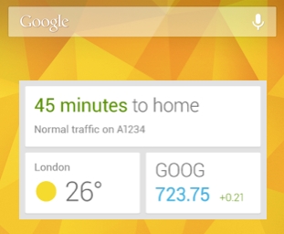
It tells you today’s weather before you start your day, how much traffic to expect before you leave for work, when the next train will arrive as you’re standing on the platform, or your favorite team's score while they’re playing. And the best part? All of this happens automatically. Cards appear throughout the day at the moment you need them
It is running at the background, checking your location, your emails, calendar and even your search history on the mobile and desktop to serve you. This sounds like the big brother is watching you, but you can get addicted to the easiness of finding the information you need with its widget pretty fast.

Getting more into our lives

I'm sure you remember the series, Back to the Future; which predicts that we would be having flying cars and hoverboards. We're still far from those as well as having food hydrators, but we're pretty close to having voice controlled home appliances, thanks to those making this technology mature enough.
Today the voice recognition technology is expanding to browsers, TV remotes, alarm clocks, watches, games consoles, and soon to glasses. It looks like we'll be having always on voice activated devices at home and real time translators [from MicrosoftDocomoClarity, Vocre] and maybe this technology will always be behind the scenes to listen us and provide some help. So what do you think, will Siri open the pod bay door for us or kill us all?

Sunday, March 03, 2013

Hello mobile application world

It had been long since my last post. I'm no longer working on roaming and positioning solutions and switched to mobile application development team in my company early 2012.

It was quite busy and fast year, leaving me no time for any post. I hope I can do post more in the future, although none will be on GSM roaming and positioning topics. Let's see what I will have to say on this pretty exciting world of mobile applications.

Saturday, May 26, 2012

Location Business Summit 2012 - Location based advertising and augmented reality

At Location Business Summit 2012, different examples of location-based marketing were given by Asif Khan, from LBMA. Below are some of those videos presented.

Bettle, trying to create advertising as impressive as the car.

Granata Pet - Snack Check-in for your dog.

Roqbot, a social jukebox and background music service for bars, restaurants, cafes, gyms, retail chains and other public venues.

Musical fitting rooms from Starhub, promoting your music download service

This one is from Thomas Alt, CEO, Metaio; augmented reality marketing campaign for Audi A1
Or this one for tablets


The interactive TV show or making the TV screen a huge touchscreen example was impressive. With the help of your smartphone and augmented reality, you can participate and respond to questions in a quiz, get individual feedback on their results and compare their performance with that of other viewers. Here is the video in German with English subtitles.


See also

Location Business Summit 2012 - Indoor Location

Google Maps 6.0 for Android
Indoor location is expected to change the marketplace radically and we heard a lot about it during Location Business Summit 2012 from both platform players like Google and vendors providing solutions to achieve indoor positioning.

Steve Gray, CTO from CSR presented a nice overview of the technical alternatives for indoor positioning. He presented two major solutions, wifi and cellular signal footprinting and pedestrian dead reckoning.

For the signal fingerprinting method, one option is to use an enterprise class wifi and positioning center from vendors like Cisco, which uses angle of arrival, time of arrival or signal strength etc to calculate position. A cheaper alternative is given as using the existing wifi and cellular signals in the environment.  After fingerprinting the environment, position is determined by interpolating the finger print data from database. After the initial finger printing, database is fed with the data from users to allow the system to adapt to the radio changes in the environment.

Apple’s blockage on the RSSI API preventing the applications to see the wifi signal strength level around is given as the major blocking issue for this method. Most consider that Apple is saving it for themselves for their own indoor positioning solution.

Many criticized Google about their indoor positioning quality saying that their data is based on the cars driving around the buildings which is not good for deep buildings like malls and airports. It looked like most (except Google) ignore Google’sMap Floor Plan Marker, which enables Google to have the indoor radio fingerprint by volunteered users. Someone mentioned that Google is also biking indoors too.

Sensewhere says fingerprinting is expensive and labor-intensive while sensor-based positioning can impact the power consumption radically. They say their “dynamic crowd sourcing” system is the solution which is completely fed by the people walking in the building with no need of initial fingerprinting of the building. Though they did not provide any technical details, they were so confident about their solution.

CSR talked about PDR which is using kinematics to estimate indoor positioning as an alternative solution to the problem. It is said that micro-electro-mechanical systems (MEMS) made it possible to determine accelaration and velocity of device. The problem with this method is the error accumulating over time / steps, introducing the need of synchronization with some known source / location from time to time.

CSR also mentioned about the recent BlueTooth v4 protocol, which can push some information (like coupon) to the phone or wake up an application. They say this interface is supported by most of the upcoming phones, including recent ones like iPhone 4s.

See also:

Location Business Summit 2012 - Operators' point of view

While there were few operators participating to Location Business Summit 2012, their point of view was discussed by TCS and Vodafone at panel.

Kristian Nylund, CEO, TCS stated that precision of network-based positioning is enough for 90% of the applications and services and handset- / application-based location can be spoofed easily for iOS and Android. He thinks that operators can differentiate themselves from OTT players with the use of network-based positioning with services like secure location (or shadow authentication) making sure that right device is being used at right location (no data roaming in China, but only during work related trips like Amsterdam visit).

O2 UK’s Priority Moments platform was brought to topic a couple of times as an example of successful operator service about location and marketing. It is a platform by O2 providing exclusive offers and special experiences from the brands you know and love, straight to your phone. Another service example was a service from a French operator which allows subscribers to be able to see the last known location of their lost phone on map. It is said both services is working at Cell ID level.

Maybe because of lack of wider contribution by operators, I heard nothing about Cell ID + TA based positioning but only Cell ID based positioning. Vodafone stated that their solutions like fleet / asset management or family finder is Cell ID based.

In response to privacy related questions, Vodafone told about their opt-in subscriber positioning permission database. If the subscriber is not asked about his preference before, he is getting an SMS when he’s about to be positioned by a service / 3rd party. He is positioned only if he replies to the SMS to confirm the positioning.

After Vodafone mentioned about their own SUPL server implementation, Google’s and Apple’s SUPL servers was taken to the discussion by the participants, noting that operators cannot use their own SUPL server with iPhone.

When it is asked, Vodafone was giving Mobile Analytics empowered by their large user base with segments like device, age groups etc as the next revenue source.

Analytics issue is highlighted by Qubulus too, giving Euclid Elements and Path Intelligence as example companies.


See also

Location Business Summit 2012

Location Business Summit 2012 was held at Amsterdam at May 22-23. Besides participating in the event for the first time, it was also my first time in the city. I enjoyed not only the city, but also the summit with its both technical and business oriented content. Various topics were presented during the summit by the diverse range of participants. In a series of posts, I will try to cover the most of the topics discussed.
Amsterdam by Claude Monet


Platform players and content providers

After Google’s presentation which is not touching any features or roadmap of their products, Microsoft’s presentation made their products look like “me too” product. Microsoft mostly mentioned about the example use cases by 3rd parties using their platform, Bing Maps.

OpenStreetMap came to the scene providing their numbers like 600K registered with 4% actively contributing users. They tried to make it clear that the quality of their maps is more than enough, still adding the quality of the corporate users’ contributions is much better. Different use cases like, OpenCycleMap, RollStuhlRouting or NavFree were presented. Usage OpenStreetMap is free in contrast to others which can charge for high volume usage. You only need to share it, if you enrich their data. You still can keep your private data private, if you are presenting it on a layer.

TripAdvisor took the attention with some statistics in the beginning of the presentation, both from their own and the market's. Their application is being downloaded 25 times per minute, while they have 23M unique users and 600M reviews/opinions in a month.

Saying 43% of the people research travel via mobile and 94% research for local activities, he exemplified some of the features of their mobile application like audio tours, self guided tours or trip ideas as well as top rated POIs, tailored for different segments and tastes.

TripAdvisor also talked about their JSON API which is for only selected partners and their mobile widget for hotels which do not have mobile experience.

Location is a great contexual filter, but it is not enough

This was a quote from Ed Parsons of Google. Saying the filter should be extended to have both intent and personalization in addition to location to make the LBS individual, he added soon each Google Maps will be unique.

Paul Berney from Mobile Marketing Association (MMA) added time to the filters to complete the “contextual relevance”, who/where/when/what. He was saying the restaurant search should be returning different results for different times of day as: highlighted the SoLoMo buzz word adding that the social filters provide more help to the users, like they value reviews of the friends more than others. MMA also quoted Gerd Leaonhard, “Advent of mobile and social is the end of lying”.

TripAdvisor was highlighting their features which are tailored for different segments and tastes.

Roaming

It was interesting hearing that much about roaming during the Location Summit as a former Technical Product Manager responsible for roaming products and location enablers at Turkcell Technology. It was either both mentioned by the presenters and asked by the audience.

In response to a question, Malvinder Jutley from Vodafone was telling that they cannot perform positioning while the subscriber is abroad.

Roaming came to the topic mostly during discussions about content, like TripAdvisor. After providing statistics like 55% of the EU travelers used smartphone while abroad and 58% turn data roaming off, TripAdvisor was saying their users want “something that is content rich, easy to use and practical while roaming”. While their application can provide the content offline preventing roaming charges to the subscriber, it turned out that they also work closely with the operators to integrate HPLMN operators’ data roaming package ads in their application.


See also

Wednesday, May 02, 2012

Roaming market: tougher times lead to innovative solutions

Roaming market is tougher than ever with the increasing regulation on the business. Considering that the European commissioner is calling roaming business as “rip-off”, we can conclude that it will not be getting any better but worse in the future.

While the operators are trying to control the expenses with more strict steering of outbound roamers, they are also trying to stimulate the usage by detecting the idle roamers and offer them different roaming packages. It is not a mystery now that the usage did not increase to the same extent as the decrease of the pricess.

Another way to increase roaming revenues can be to increase the number of roamers besides stimulating the usage. This may not make sense in the first instance, till you hear that in most of the countries almost one over three of the outbound roamers have roaming disabled when they leave the country. The rate may not be this high for European operators because of ease of travel between countries, but it is still a surprising number. It is still understandable, considering that there are many people who rarely leave their country.

Operators may have services to enabled roaming when the subscribers are abroad, but it is not easy to communicate with the subscriber as people tend to ignore the services which they do not require normally. Not all the subscribers might be aware that they can enable roaming by calling customer service from hotel, or eager to spend that time / money to do so.

Here comes the innovative solutions like Turkcell Technology's RoamActivate to rescue, which is providing a medium for the operators to reach the roaming disabled outbound subscribers to notify about ways of roaming activation. When the subscriber turns on his mobile, he gets an SMS telling about his situation and offering ways to enable roaming. In addition, RoamActivate can enable the subscriber to reach the operator call center to notify about their willingness for roaming activation. It might be mandatory by regulation to record the subscriber's order to enable roaming, preventing automatically activating roaming for the subscriber.

This unique service may look useless to some, as it is already possible to activate roaming by calls from hotel. Unfortunately, being notified of such a service and being offered to reach to the customer care free of charge from his "roaming disabled" line is making such a huge difference; so that this product is proven to be so effective in increasing the number of subscribers.

It's no surprise that tougher times lead to innovative solutions.

Wednesday, April 25, 2012

Getting more out of data roaming traffic

To stimulate usage while abroad, operators are offering aggressive roaming retail tariffs to their subscribers which are supported by negotiated IOT from partners. Because of flat rate retail tariff for a country and little margins, it is more important than ever to keep the steering effective to keep the costs under control.

Especially for data which has relatively higher IOT, the difference between the negotiated and regular IOT could be so high that even a small percentage of traffic loss to an unpreferred partner may mess all the business of your “ aggressive retail campaign”.

To achieve this, operators are working hard to tune their steering systems or support network based steering systems with SIM-based steering systems. As the loss of traffic to unpreferred partner is more serious for data traffic because of high difference of IOT for data, we need more than tuning the existing steering solutions.

Steering systems should be aware of data-heavy or data-only terminals and handle them with different settings, different preferred operator or in a more aggressive way. While the data-only terminals can be detected easily (no UpdateLocation but only GPRS UpdateLocation messages) by network-based steering systems, it is not possible for them to detect smart phones as not all the partners can send the IMEI information in the registration messages. This leads to using operator databases for subscriber - terminal type mapping which can let you know who is using a smartphone.

The definition for smartphone can be slightly different for everyone. From the data traffic perspective, we're more likely to be interested in the recent generation of smartphones with big screens and easy to use interfaces boosting data usage.

The ability to know which outbound roamer is using a smartphone may not be enough alone itself, as not all smartphone users are data-hungry subscribers. Checking their local and roaming usage history could be priceless to detect data-heavy roamers which we want to steer to our partners with negotiated data IOT.

Informa predicts that revenues from mobile data roaming will increase by a massive 246% between 2010 and 2015. With the growing trend of regulating roaming business more strictly, operators are working on data roaming business more to be able to compensate the losses.

Sunday, April 22, 2012

Drawing GSM cells on Google Maps

The GSM (radio) network is built on cells, which are served by base stations (BTS). A cell site may have multiple sectors, created by seperate antennas serving to separate angles from the same tower.

Potential real coverage of a cell

The coverage area of a cell is not certain as shown here in the figure. It can be quite chaotic and may even be built of separate "islands" of coverage, just because of geographical conditions and buildings around. The coverage area of the cell can be mathematically modeled taking the environment into consideration or better tried to be measured on the field to have the exact coverage information.

For the simplicity, each sector of a cell site can be considered as a slice of pie with the center as the tower and some depth which it can reach farmost. Theoretically the depth of a cell is 35km (6-bits time advance value), but in the cities the depth is much less. The depth of the cell can be calculated or verified by the calls made from farmost distance to the tower.

From time to time I needed to draw simplified pie-representation of GSM cells on Google Maps to be able to visualize the cell. Each cell can be identified by LAC and CID of the cell and can be described by coordinates of the tower, the start and stop angles and depth of the cell.

With my limited Javascript knowledge, I developed a quick and dirty class which can represent and draw a GSM cell on the map.

Defining cells you wanna draw as below, you can easily draw them on the map.


Adding the midpoint calculation to the class, you can show information on the cell too.


Another important function I needed was marking a time advance (TA) area, as it is used by CGI+TA based positioning method. In this method the location of the subscriber is estimated as an arc. Each TA slot is around 550 meters (for 2G). Below is a fictional cell with 2km depth.


You can see the working example and check the javascript code here. Once you populate all your cells in the module cells.js, you can play with them on the map.

Related post: converting Cell ID to coordinates

Monday, January 23, 2012

GSM positioning myths (or operators’ positioning solutions)

“Operators know –without any effort— where all subscribers are at any time with historical information”

Not just the subscribers but even some of the GSM operator employees have this idea. They even may base some ideas / solutions on this wrong assumption. But yes; as most are aware, this is a wrong statement.

Operators can determine the location of a subscriber, but not in a 1-meter precision. Worse, this has to be on demand, meaning you have to query the network for this information. Besides, this query has an impact on radio resources so that there is an upperbound on the number of concurrent queries on the network in a technically feasible way (in other words, letting subscribers to be able to talk).

In this post, we’ll go over the most common network based positioning solutions deployed on the GSM networks and their precision. Please note that not all the methods are discussed here, but only the most common ones. There are higher precision solutions than the ones described here, but most are not financially feasible requiring serious hardware investment. They are rarely used unless it is mandated by the regulatories. Below, the solutions are grouped in the way they are accessed or operating.


Mobile Termination Location Request (MT-LR)

Solutions in this category are queried to check the position of the subscriber on the network on demand. They query different nodes on the network to collect the position information and return the result to the service triggering the query.

MPS might be the most known solution in the category. Its accuracy is better than cell level, as it can return a slice of the cell with the calculation of the subscriber’s distance to the antenna.


If the antenna is serving only to a specific range of 360 degrees area, this results as an arc for the position of the subscriber. The ellipsoid arc is specified with the coordinates of the antenna, the inner/outer radius and start/stop angles. While the depth of the arc is about 550 meters (for 2G) in general, the size of the area depends on the antenna angles and the distance to the antenna. So the size of the arc can be >550m wide area for the downtown areas, but it can be a couple of kilometers for the rural.

As the distance to the antenna is calculated with time advance (Ta) information on the GSM network, this positioning method is also referred as CGI+TA method too. As this method requires active paging of the subscriber, it consumes some radio resource during the operation. As the radio resource is a quite valuable and limited resource for the GSM networks, it is clear how “expensive” the positioning in terms of both license and radio resources. Besides being expensive, the radio capacity introduces limits on how many positioning queries you can perform on a single cell.

CGI based positioning is another alternative in this category. Compared to CGI+TA, it provides a coarser area using only the serving cell ID of the subscriber. While the uncertainity area is as big as the cell itself, it is adequate for most of the 3rd party services. GSM vendors state that this method provides almost the same precision with CGI+TA method in the cities. CGI of the subscriber can be queried from the network without consuming the valuable radio resources but this will return the last CGI which the subscriber made any activity (mobile originated (MO) / terminated (MT) call/sms or data) or performed location area change. Alternatively, subscriber can be paged before the query to find out the active CGI of the subscriber.


Network Induced Location Request (NI-LR)

This platform works on the CGI+TA level. The main difference within them is that NI-LR does not need to be pulled for positioning. As it is intended for emergency calls, it queries the location of the call originator and pushes this information to a specific node on the network for each emergency call. Another pro of this method is that it can provide the location of the SIM-less subscribers making emergency call too.


Monitoring based systems

The solutions described above are active nodes, exchanging messages and consuming resources on the network. Considering messages are exchanged on the network for the mobility of the subscriber, one can consider monitoring these messages to be able to extract location information. This kind of working has the benefit of low effect on the network and ability of knowing all subscribers’ location at a time.

Here we have feasibility issues in terms of number of (and cost) monitoring probes and the amount of data processed. For a huge network, it is not financially feasible to monitor every single cell (BSC/BTS). Because of this, most operators monitor MSC-BSC communication (A-interface) only. At this level, Cell ID of subscribers is visible only for those performing any MO/MT activity or changing the “location area”.

Location area is a virtual concept, used to group a number of cells together to reduce the signalling cost. That’s why passive subscribers changing cells are not visible on this level, as long as they stay in the same location area. Based on this information, it is clear that the precision of such monitoring system is at “location area” scale. It may return cell level information but this information is the first cell the subscriber enters the location area, but not his active cell ID.


In short

With all the information above, we can sort the positioning solutions ordered with their precision as CGI+TA >> CGI >> A-interface monitoring.

Operators can locate the subscriber, but only within an area which is not small and varied depending on the area. Also, it is not possible to locate all subscribers at a time at the moment.

Finally, to comfort the subscribers, I have to note that most GSM operators are taking the subscriber privacy as serious issue and perform positioning only if the subscriber or the legal authorities (like emergency call cases) asks for it.

Sunday, September 11, 2011

Sponsored networks and outbound roamer steering

There are different solutions allowing small operators to be able to inter-operate with quite large number of partner operators without the need of individual interworking agreements. Such solutions enable the new operators a global coverage with the support of the sponsor network.

Both sponsored and sponsor networks employ some products (which some might be called as roaming replicator), to make the message originated from sponsored network look like it is sponsor network’s traffic. Sponsor network route the traffic for the sponsored network properly too, which allows the sponsored network to access all the partners of the sponsor network.


As shown in the figure, when a subscriber attempts to camp to a network which receives service from a sponsor network, the registration request arrives from sponsor network to the HPLMN HLR. As the replicator products change both SCCP calling and VLR addresses with IMSI, from the point of HPLMN the subscriber is like being abroad in sponsor network country.

Issues with steering
Operators may prefer their outbound roamers to register to certain operators even though they may have roaming agreements with many operators in the same country. The motivation of having “preferred” partners can be cost (having discounts) or technical reasons (like better Camel / data support).

Steering solutions determine the country of the outbound roamer and try to steer the subscriber to a preferred partner using different methods. While one of the methods is network based steering which intercepts the subscribers’ registration messages, another method is SIM based steering which updates the preferred list of the subscriber’s SIM properly for the country.

For the sponsored network as the VPLMN, the HPLMN believes that the subscriber is trying to register to sponsor network actually. Besides this confusion, concluding the subscriber is at another country (Country Y instead of X) is a worse problem. There might be different settings for two countries and if the parameters are looser for the sponsor network’s country, this will cause problems for you.

The sponsor network might be a preferred partner and this prevents you to steer the subscriber to the preferred partners in country X. This may not be a problem if the sponsor network is “more preferred” than your preferred partners in the sponsored network’s country. But for the other case, this may mean that you lose some revenue.

Even though the sponsor network is more preferred than any preferred partner in the sponsored network’s country, you still should fix this case with configuration of the steering solution; to be able to retrieve correct reports grouped by countries.

Solution
Sponsor networks let the partners know about the sponsored network in general. They may publish the sponsorship as well the GT prefix for the VLRs used for that sponsored network. What you should do is to look for such publications from partner networks and alter the settings for your steering solution.

You will possibly need to create a new network to represent the sponsored network with the published GT range from the sponsor network's GT range. Considering your steering solutions allows that, then you should assign this new created network to the country / zone of the sponsored network.

With such setting, you will be able to correctly perform steering configuration for both sponsor and sponsored networks' countries. As roaming business is a considerable part of the revenues of the operators, having correct steering settings can be crucial to keep the costs minimized.

Saturday, July 23, 2011

Trusting Google blindfolded

Or maybe I should have picked a title like “do not trust Google Maps picking a route for you”. It was my first time using Google Maps when I was driving between different spots during the vacation. It was always OK to use it in the city or at the main roads interconnecting cities. With this experience I had a trust using Google Maps on the smartphone so that I did not even need to follow road signs.

All rights reserved by jhellfire2000

Ending up in the field with pomegranate trees  following this route for Dalyan to Sarıgerme made me notice that Google may have erroneous data too.

Things started to go wrong at step 3, seeing that the road is not as straight as Google thinks so; but it was heading where Google promised to. I kept following and ended in the field. Too bad I was not driving a 4WD to follow Google's route comfortably.


It was not Google's mistake actually as Google is working with local providers for maps, like this map was provided by BaşarSoft. Checking the web I noticed I am not the only one having this problem.

This little experience made me notice there is still a lot to depend on online maps blindfolded.

Friday, July 01, 2011

Touristy spots of Istanbul

Coming across the World touristiness map and The Geotaggers' World Atlas by Eric Fischer online, I wondered Istanbul’s popularity map. While Eric Fischer’s map for Istanbul could give an idea about the popular spots, what it really provides is the mobility map of the photographers.

The different colors represent different modes of transportation: Black is walking (less than 7mph), Red is bicycling or equivalent speed (less than 19mph), Blue is motor vehicles on normal roads (less than 43mph); Green is freeways or rapid transit.

While world touristiness map provides the popularity info, the resolution is too low to check the popularity at the city level.

Inspired with both ideas I downloaded the locations of all 100K+ geotagged pictures taken around Istanbul at Flickr. Below is the heatmap produced with pictures since the beginning of 2010. While it would be faster to create small grids of the city and download only the number of pictures for each grid (like what "world touristiness map" did possibly), this would not be able to create a high precision map. Because of this, I tried to download all the picture coordinates.


It is no surprise that the most hot area is the historical part of the city and by Bosphorus. The spots on the sea are mostly on the route of ferry lines.


Knowing the city a bit, you could expect this result before trying to plot the pictures. But still if you do not know the city very well, it can teach you new spots close to the city to see like those small red dots at northern part.

Thursday, June 30, 2011

Turkey's earthquake density map

Last year, while checking GoogleMaps' API I used Kandilli Observatory and EarthQuake Research Institute's recent earthquakes data to plot on the map.

For some time I was thinking to implement a heatmap layer for Google Maps, but could not have a chance to do so. Coming across Patrick Wied's code for the same purpose, I tried to play with his code a bit. Remembering the old earthquake map, I used Patrick's code to create a earthquake density map for Turkey using the Kandilli's data.


Above is a snapshot for the produced map. Colors changing blue to red implies increasing earthquake magnitude or more earthquakes around that area. Click the image to see the active version of the map.

Monday, May 16, 2011

Effect of network-based steering on international traffic

Network-based steering is one of the options to redirect the outbound roamers to the preferred partners and works by refusing registration messages from outbound roamers. By its nature, this causes some additional load on international links, which may mean additional cost for international connections. The amount of this additional load depends on several parameters such as the number of outbound roamers or preferred partner coverage performance. Though the exact value might be quite different for each network, an average of more than 5% additional load can be given as an educated estimate. This may mean that network-based steering may increase operators’ international connection costs.

SIM-based steering

Though it looks inevitable to have this additional load on the links, it is possible to reduce this overhead by employing network-based steering only when we have to. In other words, using adaptive SIM-based steering can reduce this overhead. SIM-based steering can be considered as the ultimate solution to steering. It is the best possible way of redirecting subscribers, making the handset work for the operator instead of trying to guess what is happening from the Home Public Land Mobile Network (HPLMN) side.

Using this approach, the handset is forced to pick the preferred partner as long as its service is available. It also makes sure that the handset switches back to the preferred partner even if it had to use an un-preferred partner because of coverage issues. It allows operators to have different levels of preferred partners, not just preferred and un-preferred partners. As operators can trust the handset now, knowing it will camp to a preferred partner if possible, it also allows subscribers to register and start using voice and data services more quickly. Removing the need for network-based steering also removes the overhead on international connections and increases steering performance.

However, most of the benefits of SIM-based steering depend on a specific command called Refresh. Without it, the settings will not be applied before the handset is restarted. Yet this command is not supported by every handset or SIM card profile. It means that the performance of SIM-based steering depends on the distribution of handset models as well as different SIM profiles on the network.

To maximize the benefits of SIM-based steering, it’s therefore vital to plan ahead while making SIM purchases to make sure that the new SIM profiles support this command even though there is no close future plan for SIM-based steering deployment. Even then, operators may still need to employ network-based steering for unsupported handsets as it is not possible to control the distribution of the handsets.

Roaming disabled subscribers

While network-based steering introduces an extra load on international links, it may need to be accepted in certain cases. Where it should definitely not be accepted is when it relates to steering outbound roamers who have their roaming disabled.

The percentage of roaming disabled subscribers who have their handset turned on while they are abroad is relatively high. The exact rate can be quite different for each network, but it can be around 30%. And worse, these handsets generate almost twice more registration messages per unit time, compared to regular subscribers. Based on these numbers, it’s clear that almost half of the registration requests are generated by roaming disabled subscribers. Applying network-based steering on these requests brings us nothing but pointless overhead traffic on international links.

Integrating and configuring the steering system properly is the solution to this problem. The steering system can access the operator’s internal database for this information or query the GSM nodes. Another solution can be to use passive mode solutions with steering on the return path.

While these solutions are to reduce the unnecessary cost of network-based steering, a much better option could be to turn those roaming disabled subscribers into roaming enabled, revenue generating ones.

See also Outbound Roamer Steering and Mobile Data Boost

Sunday, May 15, 2011

Outbound Roamer Steering - Mobile Data Boost

The introduction of iPhone boosted the smartphone market as well as mobile data usage. Informa reports that by 2013 there will be one billion smartphones in use, thanks to iPhone and Google’s Android operating system. Each year, both the number of smartphones and their share in total number of handsets is increasing. Tablet computers (again triggered by Apple’s iPad) are another gadget pushing the mobile data usage a step further. According to Gartner, tablet sales will surpass 200 million by 2014.

Both smartphones and tablets consume a huge amount of mobile data, increasing the share of data revenues for operators. In parallel to this trend, Informa predicts that revenues from mobile data roaming will increase by a massive 246% between 2010 and 2015.

Within the context of the previous post, we have to pay special attention to data with our outbound roamer steering solutions.

Ensuring smartphones’ proper work on the network

As smartphones are becoming such an important part of the roaming business, we need to ensure that service is as seamless for them as it is for regular handsets. Unfortunately, the behavior of some smartphones can be different from regular phones as they are designed to be something more than just “phones”.

An example can be some specific models’ failure to interact with network-based steering solutions. Unlike the plain handsets they may accept having only data connection without any voice connection, resulting them to be stuck in a condition where the subscriber is not reachable for any calls or SMSs. Worse, this condition is not visible to the subscriber unless he tries to make a call. Although the solution to this problem can be as easy as enabling steering of GPRS messages, without such a care we’ll end up with unhappy customers and loss of potential revenues.

Segmentation

In the old times where the GSM traffic and revenues consisted of voice and SMS mainly, outbound roamers were tried to be redirected to cheaper voice partners. While this is still the case for most of the subscribers, with the increasing data traffic share we have to make sure data-heavy subscribers are redirected to the cheaper data partners. Steering systems segment the outbound roamers normally as prepaid, postpaid or VIP subscribers and treat them differently, but now we need a separate segment for data-heavy subscribers.

The question here is how to determine the data-heavy subscribers. Billing system integration is a proper option allowing the steering system to check the roaming history of the subscriber to determine if he’s a data- or voice-heavy subscriber. For the cases where the steering system does not support this kind of integration or operator cannot provide such an interface, checking the device database (IMEI) for the subscriber could be another option. Although this works on the assumption that all smartphone users are data-heavy subscribers, this is still better than doing nothing. And it can work properly for the terminals like data modems.

Saturday, May 14, 2011

Some missed out aspects of outbound roamer steering

Roaming revenues have always been an important part of the operator’s income. The EU regulations introduced limitations of roaming charges both for wholesale and retail tariffs. The roaming revenues were expected not to be effected massively, with the idea that lowered prices would boost the usage. After several years with the regulations in practice, many operators argue that the usage did not increase as expected resulting in decreased roaming revenues. The regulations have also a water bed effect on the non-EU operators. To be able to compensate the revenues the EU operators may charge more to the non-EU ones which affects them too.

We hear a lot about the EU commissioner’s views on the roaming tariffs, which can be summarized as “no difference between the cost of making a call in one’s home market and across borders”. This is an indication that the roaming business will not get relief but will have lower margins each year. Reading news reports from non-European countries which ministers say the roaming charges are too high and should be lower, shows us that EU regulations are inspiring other countries too.

With these trends in the roaming business, operators are paying extra attention to the details to be able to maximize the profit while establishing subscriber stickiness. Outbound roamer steering has always been a way of maintaining higher profits from outbound roamers by redirecting them to the preferred roaming partners, though its nature is changing with the changing trends in the GSM world too. As a vendor with widespread roaming products serving to millions of subscribers and with close relations with operators, I would like to highlight a couple of issues about outbound roamer steering in the following posts.

Saturday, January 08, 2011

Mobile apps gold rush

Ever impressed with the success of applications like Angry Birds for smartphones and it looked tempting working on your own application? Reading statistics like 12+ million paid copies and 30+ million free versions for a game which does not look quite complex might make anyone think and calculate about it ("12 million times that money and 70% of that ..."). It may even make you dream about becoming your own boss reading stories of people quitting their daytime jobs for iOS development.

Is it really that easy to be different and more successful than those more than 300.000+ applications? Considering thousands of publishers trying to achieve this, it is clear that it is not that easy.

Steve Costello writes about the driver of the success of Angry Birds:
According to Hed, the driver for the success of Angry Birds has been the “relentless social media buzz,” which has helped it stand-out from the raft of other mobile games products available for iOS and other platforms. “Getting featured in the app stores is important, but it does not guarantee automatic success. Working together with great brands helps, as does having a tremendous product. At the end of the day, being phenomenally successful puts you in the news and generates increasingly more interest and more publicity,” he says.

"The most successful developers tend to be time-served veterans, who can trace their heritage back to early Palm OS and/or Symbian titles" says Steve on another blog post. He also adds that to be able to successful you have to adapt yourself to put yourself in the best position for the future.

Perhaps there is a message for the developers currently working away either alone or as part of a small team, struggling to generate interest in a crowded market dominated by established giants. The most important thing is to keep going, and continually evolve to target whatever the market “sweet spot” may be. Admittedly, this is no guarantee of success – but it does seem to be the best way to maximise the opportunities.

How do you feel about trying your chance on your application after such reports?

Wednesday, January 05, 2011

Techno-junkies

Some time ago I watched some videos shot by the participants of Turkcell’s customer insight studies. The segment considered was the university students and they were given video cameras and asked to stop using mobile phones for some time. The cameras were for them to share their experience and thoughts.

Though I do not remember the videos in detail, I remember how they were complaining about the lack of communication. Even though some of the videos were a bit exaggerated, their message was clear and not surprising: Mobile phones became a huge part of our life.

A recent post at Engadget talking about a research by International Center for Media and the Public Agenda (ICMPA) reminded me that customer insight study. ICMPA’a research is sure more comprehensive but shares a similar idea: A class of 200 students living without any media (cell phone, iPod, television, car radio, magazines, newspapers and computer) for 24 hours and blog about their experience.

According to a new ICMPA study, most college students are not just unwilling, but functionally unable to be without their media links to the world.

The research study is not just showing that we’re incapable of living without media, but points out that we are actually addicted to it suffering withdrawal symptoms, just like real addicts.


Many students described their reactions to going without media for 24 hours in literally the same terms associated with drug and alcohol addictions: In withdrawal, Frantically craving, Very anxious, Extremely antsy, Miserable, Jittery, Crazy.

Do you think you could succeed (no texting, no Facebook or IM-ing) or could not resist to the desire and fail to complete assignment as some students did? Are you one of those junkies?